Struve Geodetic Arc

By Cornelia Huthmann
What is the Struve Geodetic Arc?
The Struve Arc, or more precisely the Scandinavian-Russian Meridian Arc, is a scientific historical landmark. It consists of a 2,821-km long chain (1,753 mi) of geodetic survey points established along the meridian arc from Norway to the Black Sea through ten countries. The project aimed to demonstrate the flattening of the Earth at the poles. That, in turn, would help determine the exact shape and size of the Earth. The survey work was led by the astronomer Friedrich Georg Wilhelm Struve between 1816 and 1855.
Disclosure: This article contains affiliate links. Making a purchase through an affiliate link will mean a small commission for this website. This will not affect your price. Privacy policy.
The original arc consisted of 258 main triangles with 265 survey points. Today, 34 of these points can still be seen. These are marked, mostly on elevations in the terrain, by various markers such as drilled holes in the rock, iron crosses, cairns, or even obelisks. Some can only be reached by long hikes, while other survey points can be found not far from the road. Selected points are described in more detail below.
One end of the measurement series is located in Hammerfest, Norway, while the other is in Ukraine near the Black Sea. The UNESCO designation also includes the Tartu Observatory in Estonia, Struve’s former workplace, which houses an interesting exhibition on the project.
Why is the Struve Geodetic Arc a UNESCO World Heritage site?
The Struve Arc has been listed as a scientific World Heritage site on the UNESCO World Heritage List since 2005. The project was an important milestone in the development of geosciences and topographic mapping. “It is an extraordinary example of scientific collaboration among scientists from different countries,” according to UNESCO, “and of collaboration between monarchs for a scientific cause.” The Struve Arc is a symbol of international scientific cooperation and an important testimony to the history of geodesy.
It is a transnational World Heritage site and includes the following countries: Norway, Sweden, Finland, Estonia, Latvia, Lithuania, Belarus, Russia, Ukraine, and Moldova.
Below is a map of all the existing 34 points in blue, with a few nearby UNESCO sites added in red, such as the Fortress of Suomenlinna in Finland, Church Town of Gammelstad, Luleå, in Sweden, and Vilnius Historic Center in Lithuania.
Note: Until the war is over, we do not recommend visiting Ukraine, and we can’t know until then to what extent its UNESCO World Heritage sites have been damaged.
What can you expect on a visit to elements of the arc?
I visited the measuring points in Norway, Finland, Sweden, and the Baltic States in 2021 and 2022. The other measuring points are located in Belarus, Russia, Moldova and Ukraine. All measuring points I visited are described in detail here (in German – use a translation app).
Here are some prominent or easily accessible points:
Hammerfest measuring point in Norway
The beginning of the Struve Arc is in the town of Hammerfest in northern Norway. The drive to Hammerfest leads along a fjord. There are hardly any tourists here; they’ve all turned off to the North Cape. In Hammerfest’s old town, the colorful wooden houses are grouped on the hillside around a futuristic church. The town has a fishing port and a cargo port.
I found this Struve point easily; it’s located in the middle of town. It includes explanations of the project, as do many of the other points.
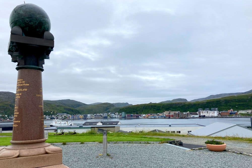
Hammerfest is a typical Norwegian port town and lies somewhat off the route to the North Cape. However, for anyone who wants to see selected points of this World Heritage site, a visit to the beginning of the meridian arc is a must.
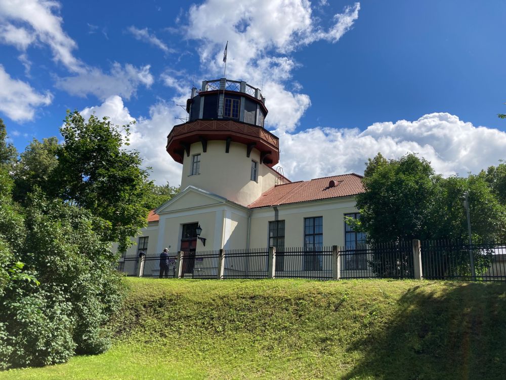
Dorpat Observatory in Tartu in Estonia
The historic observatory in Tartu is open to visitors. This is where Struve planned his meridian survey. For me, the highlight in Tartu was climbing the tower with its view of the surrounding area and its descriptions of the directions to the next points of the arc. During my tour of the observatory, I was able to visit various exhibitions, including interactive presentations meant especially for younger visitors.
The observatory was built in 1811 at the German University of Dorpat and was the home of many prominent astronomers. It became internationally famous for its large refractor, designed by Josef Fraunhofer, which was put into operation here in 1824. The observatory was led by German directors until 1900, including Friedrich Wilhelm Struve.
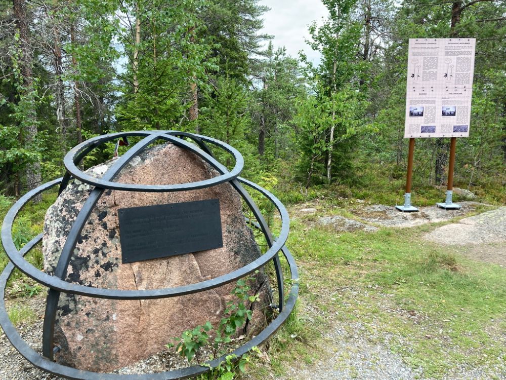
Aavasaksa measuring point in Finland
I mention this point because it’s located directly on the border river between Finland and Sweden and offers a phenomenal view from the adjacent observation tower. The meridian stone is located on a mountain near the town of Ylitornio, near the Arctic Circle. I parked at a ski and hiking area and had to search for the way. The best route leads via the historic lodge to the observation tower. The Struve Stone is located right next to it and includes detailed information and photos. It’s a pleasant hike: a welcome stopover for anyone traveling through.
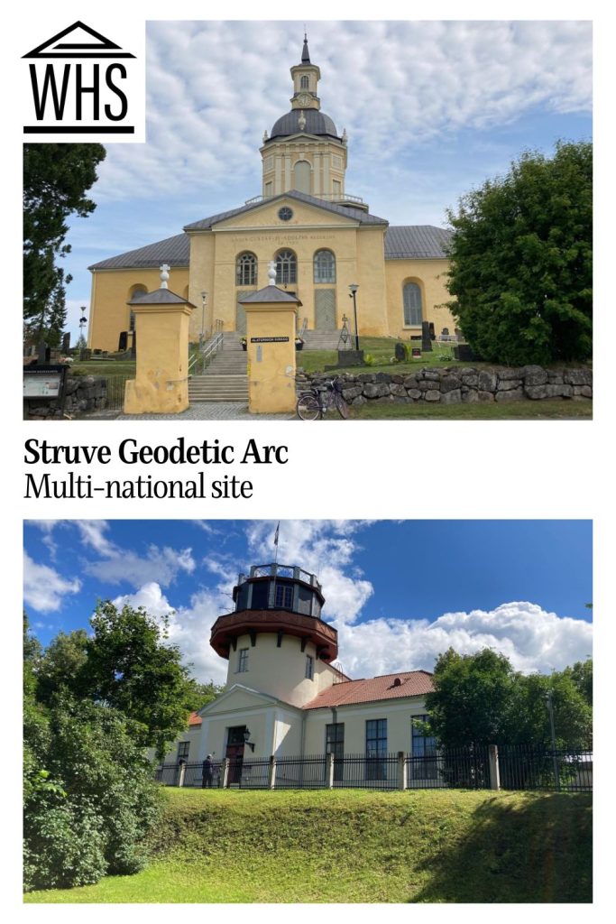
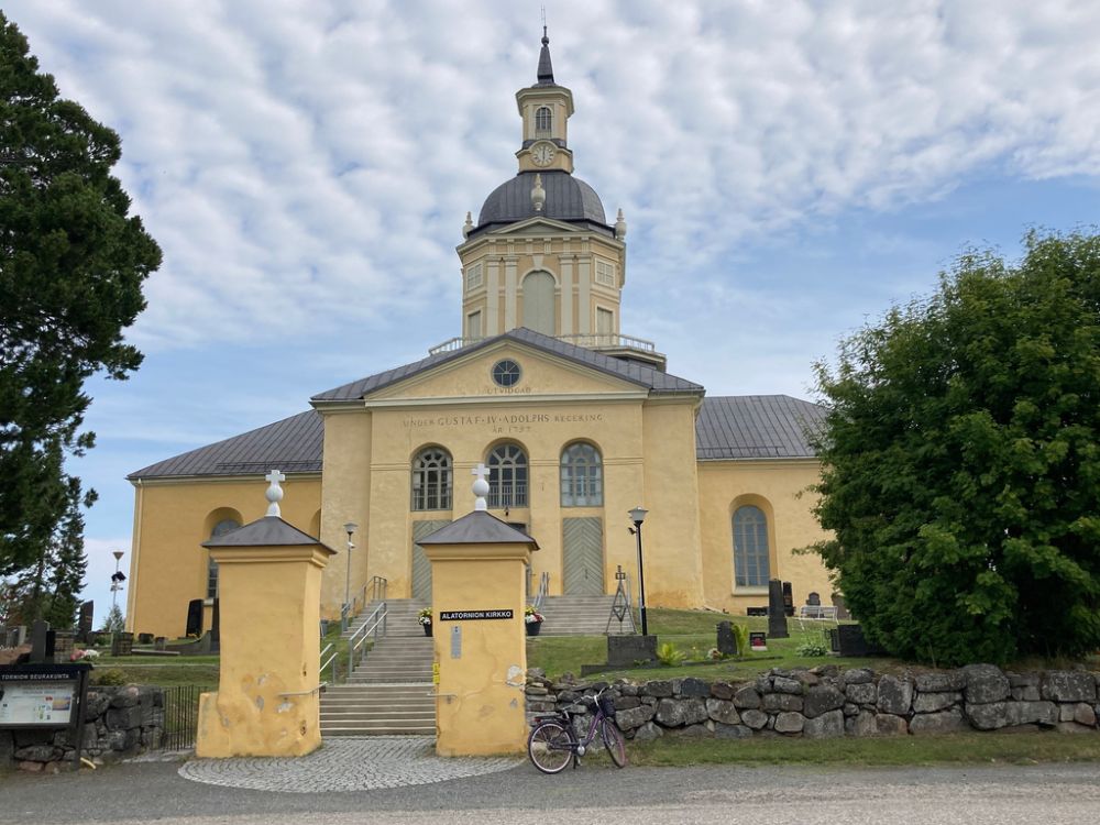
Old Church of Alatornio in Finland
Located near the border town of Haparanda at the very northern end of the Gulf of Bothnia, the church used by Struve stands on a hill. When I arrived, I was even given an informational flyer about the meridian arc. The measuring point was the bell tower itself. Incidentally, this isn’t the only point where Struve used already-existing buildings.
With its beautiful interior, the church is a good stop on the way north or south along the points of the arc.
Meškonys measuring point (Lithuania)
I searched for and found several measuring points in Lithuania. I’m mentioning the Meškonys measuring point in particular because it is right next to the geographical center of Europe. Meškonys is easy to find, located on a hill right next to the road, and is very similar to the others in Lithuania. The geographical center of Europe is at the next exit – and it’s definitely worth a visit!
Is the Geodetic Arc worth visiting and what sorts of travelers would like visiting it?
Fundamentally, this World Heritage site is for those specifically interested in geography, physics, or the history of science. However, many of the individual points are not easily accessible. This may be because of current events – the war in Ukraine at the moment – or because they involve long hikes.
This could also be a reason why hikers to less-visited places might be interested in this special World Heritage site. For hikers, it’s not worth visiting just one measuring point: doing a series of the points on the arc would be more enjoyable.
Some of the locations, if you’re in the area, are worth visiting for non-hikers: the obelisk in Hammerfest, for example, or the observatory in Tartu.
For anyone interested in the Struve Arc, I would say that Tartu Observatory is a must, as the basics are taught here. The site is not only interesting and recommended for World Heritage visitors, but also for anyone interested in a historic observatory, large telescopes, and general scientific history. There is also a science fiction section for younger visitors.
Tips for visiting the elements of the Struve Geodetic Arc
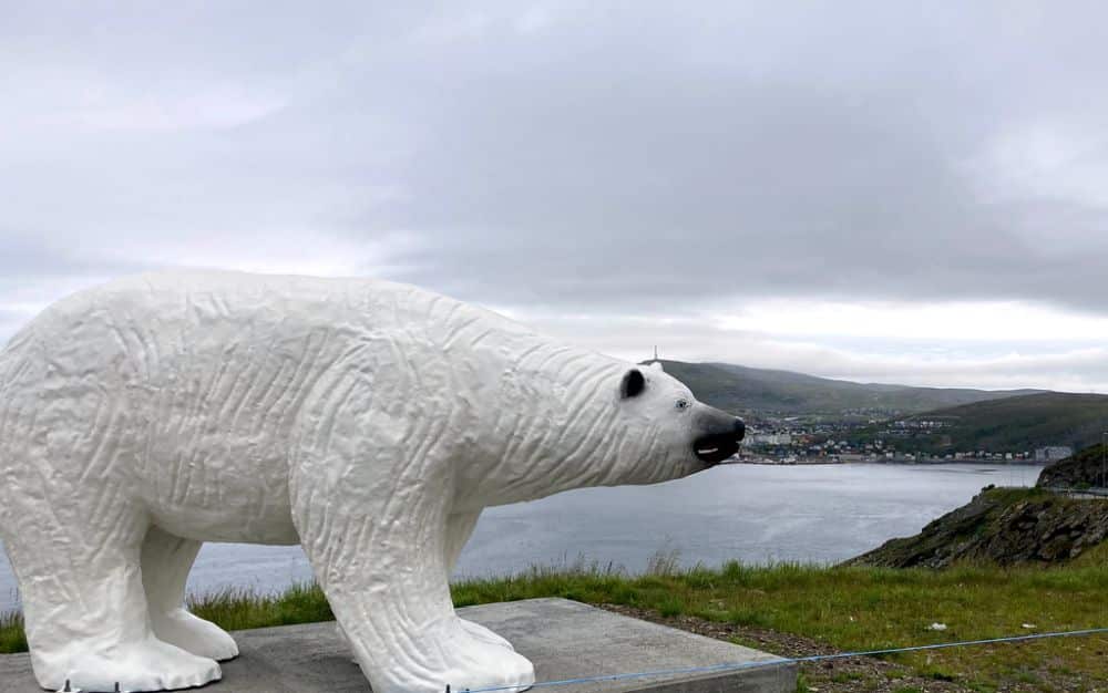
Hammerfest: A statue at the town entrance celebrates Hammerfest’s famous Polar Bear Club. It makes a nice photo stop.
Tartu Observatory: Tartu is an old Hanseatic city with a historic center that’s worth seeing.
Aavasaksa measuring point: Be sure to climb the 71 steps up the tower and visit the historic lodge.
Meškonys measuring point: It’s a short hike to the Geographical Center of Europe.
Book your accommodations in Hammerfest, Tartu, Aavasaksa, Haparanda (near Alatornio Church) or Vilnius (near Meškonys).
Where are the different parts of the sites?
Here are the addresses of the particular points recommended above:
- Hammerfest Obelisk: near Meridiangata 10 in Hammerfest, Norway. Parking is available.
- Tartu Observatory: Lossi 40 in Tartu, Estonia. Paid parking is available nearby.
- Aavasaksa Measuring Point: 95620 Ylitornio, Finland. The parking lot is near the restaurant at Aavasaksanvaarantie 281, 95620 Aavasaksa.
- Old Alatornio Church: Alatornion hautausmaa, Kirkonmäentie 85, 95450 Tornio, Finland.
- Meškonys Measuring Point: 15130 Vilnius District Municipality, in Lithuania, on Road 5207 after the Juodežerių g. junction.
All of the above-mentioned measuring points and selected locations are generally only accessible by car and, in some cases, by hiking. Only Tartu has an airport nearby.
For more information, here are the websites for each of these locations:
- Hammerfest: The obelisk and explanations are freely accessible 24/7. The Reconstruction Museum in Hammerfest has an exhibition about the Struve Geodetic Arc as well.
- Tartu Observatory: Information, opening hours and fees on their website.
- Aavasaksa Measuring Point: Measuring point, tower, and lodge are freely accessible 24/7. More information here.
- Alatornio Old Church: Website (only in Finnish).
- Meškonys Measuring Point: The location is freely accessible 24/7. More information here.
Have you been to any of the elements of the Struve Geodetic Arc? If so, do you have any additional information or advice about this UNESCO World Heritage site? Please add your comments below!
- About the author
- Posts by this author
Text and photos by Cornelia Huthmann of 5 Reisende. She is now 70 years old and, since she retired, she’s decided to visit all the UNESCO World Heritage sites in Europe. To do this, she converted a Dacia Dokker into a mini camper (it’s called Dobby ;)) and she’s traveled more than 120,000 km across Europe in the last four years. She’s visited almost all the World Heritage sites on the European mainland and the UK, but still has a few islands to visit. Follow her on Instagram.